Our yachts board here, in downtown Cabo, each at its own dock (the Sea Ray 65 at Fisherman's Landing restaurant, by the Cabo Escape terminal); your exact dock and a map link come on your boarding pass. It is a walk from the Médano Beach hotels and a taxi ride from the resorts along the corridor.
A rocky point at the foot of Land's End, inside the bay. The water is calm and clear, and reef fish swim close to the surface. The first snorkel stop on most charters.
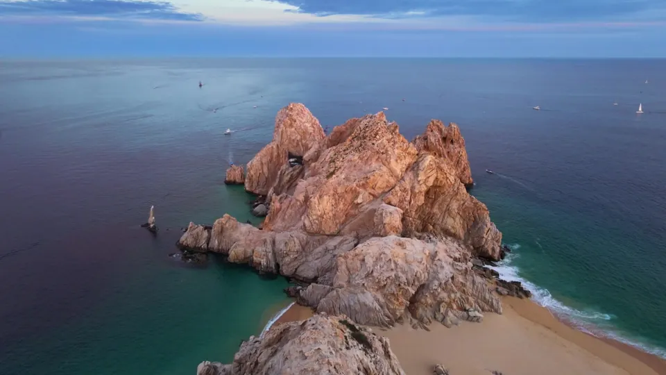
The granite arch at the very tip of the Baja peninsula, where the Pacific meets the Sea of Cortez. The best angle is from the water, which is why every route passes it.
A sheltered horseshoe cove up the coast, with reef along both points and clear water. One of the favorite snorkel stops in Los Cabos, and worth the ride on charters of four hours or more.
Tap a month for water and air temperature, rain, sunrise and sunset, and what that month is best for.
Month
Whale season
Best
Best
Good
Good
Off season
Off season
Off season
Off season
Off season
Off season
Off season
Good
Snorkeling
Possible
Possible
Possible
Possible
Possible
Good
Best
Good
Good
Best
Best
Good
Sunsets
Best
Best
Best
Good
Good
Best
Good
Possible
Possible
Good
Best
Best
Days on deck
Best
Best
Best
Best
Best
Best
Good
Possible
Possible
Good
Best
Best
Water
74°F23°C
72°F22°C
72°F22°C
72°F22°C
75°F24°C
77°F25°C
81°F27°C
85°F29°C
85°F29°C
85°F29°C
81°F27°C
78°F26°C
High
77°F25°C
77°F25°C
79°F26°C
80°F27°C
81°F27°C
84°F29°C
88°F31°C
88°F31°C
88°F31°C
87°F31°C
84°F29°C
79°F26°C
Rainy days
5%
4%
2%
1%
2%
5%
10%
32%
34%
10%
7%
5%
Sunset
5:56
6:16
6:29
6:40
6:53
7:06
7:08
6:52
6:23
5:54
5:35
5:37
BestGoodPossibleOff season
How these ratings are calculated
Whale season: Official season set every year by SEMARNAT: December 15 to April 30 for 2025 to 2026. January and February are the peak.
Snorkeling: Best with water at 80°F (27°C) or warmer and rain on 12% of days or fewer. Good from 76°F (24°C).
Sunsets: Best with rain on 7% of days or fewer and daily top wind of 13 mph (21 km/h) or less.
Days on deck: Best with highs between 76 and 86°F (24 and 30°C) and rain on 10% of days or fewer.
Temperatures are in °F with °C below. Water and air temperatures are 10-year averages (2015 to 2024) from NASA POWER and NOAA Coral Reef Watch. Rainy days are days with at least 1 mm of rain. Sunset is on the 15th of each month, Cabo time.
Forecast
The days ahead.
The forecast covers about nine days. For dates further out, the planner shows typical conditions for that exact week.
Cabo San Lucas forecast
Loading the forecast
Practical tips
The small things that make the day.
Getting to the marina
Marina Cabo San Lucas is in downtown Cabo, a walk from the Médano Beach hotels and a taxi or rideshare from the resorts along the corridor. Each yacht boards at its own dock inside the marina; your exact dock and a map link come on your boarding pass. The Sea Ray 65 meets you at Fisherman's Landing restaurant, by the Cabo Escape terminal. Coming in on a cruise ship? The cruise ship schedule shows which ships are in Cabo each day.
Cabo time
Cabo is on Mountain Standard Time all year, the same as Arizona. No daylight saving. Every time in your confirmation is Cabo time.
Money and tipping
Rates are per boat and include 16% tax. The customary crew tip is 15%, paid in cash on board, in dollars or pesos. There is no dock fee on any of our yachts.
What to bring
Reef-safe sunscreen, swimwear, sunglasses and a hat, a light layer for evenings, and cash for the tip. Towels are included on the Sea Ray 36, Sea Ray 40 and Azimut 45; bring your own on the others.
If you get seasick
The bay and Land's End are usually calm. The Pacific side and open water have more swell. Take something before you board, sit toward the back of the boat and keep your eyes on the horizon.
Weather and port closures
The Port Captain decides when the harbor closes, usually for storms or strong wind. If the Port Captain closes the harbor, your charter moves to another date or your payment comes back in full.
Kids on board
Children are welcome. Tell us their ages in the request so the right life jacket sizes are on board. Every yacht except the Chaparral 28 has a head (bathroom).
Wildlife and fishing
Sea lions and whales are protected in Mexico, and captains keep their distance. Fishing happens only on the McKinna 70's sport-fishing charter, with the licenses included; the other yachts have no fishing permits, so fishing gear stays on land.
Still deciding?
Tell us the date. We will suggest the yacht and the route.
A written reply within 2 hours, 8 AM to 8 PM Cabo time.